

Flooding along the Missouri River
7-2-2024
A flood warning is extended until late Tuesday evening for the following rivers in Missouri, Nebraska, and Iowa.
Missouri River At Rulo affecting Richardson and Holt Counties.
Missouri River At Nebraska City affecting Otoe and Fremont Counties.
Missouri River At Brownville affecting Nemaha and Atchison Counties.
Missouri River at Plattsmouth affecting Mills and Cass Counties.
Missouri River At Omaha affecting Sarpy, Pottawattamie and Douglas Counties.
Missouri River Near Blair affecting Pottawattamie, Harrison and Washington Counties.
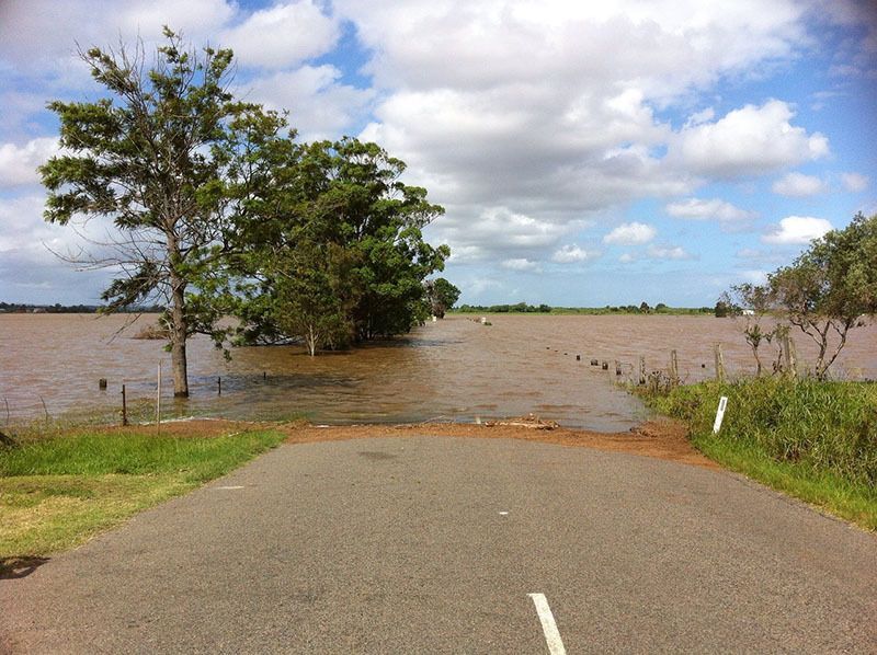
Turn around, don't drown when encountering flooded roads. Most flood deaths occur in vehicles.
Additional information is available at water.noaa.gov.
6-25-2024
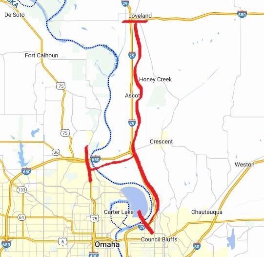
I-29 is closing between 25th St on the North side of Council Bluffs to I-880/Loveland exit at 11 AM or before if rising water moves faster. Also, 680 will close from the Mormon Bridge in Omaha to I-29.
Flood Warning
6-25-2024
A flood warning is in effect for eastern Nebraska along the Missouri River, including Omaha.
After recent heavy rains in South Dakota, northeast Nebraska and northwest Iowa, the Missouri is expected to crest in Omaha very early Thursday morning at 35.1 feet and remain at flood stage until next week. The U.S. Army Corps of Engineers is warning boaters to stay off the river due to quickly rising and dangerous water levels and significant debris coming downstream, including large trees.
The City of Omaha has closed N.P. Dodge Park including the marina, and Freedom Park. Pershing Drive, north of Interstate 680 could close as soon as Tuesday. Riverfront Trail north from Crown Point/Ida Street to Pershing Drive, and from the Mormon Bridge to north of N.P. Dodge Park is closed. N.P. Dodge Park Trail and the Riverfront Trail South from Hickory Street to Missouri Avenue are also closed.
Precautions including sandbagging are underway at the city’s two wastewater treatment plants.
At the Lewis and Clark Landing, the urban beach, Riverfront Plaza, marina and sand volleyball courts are closed. The remainder of the riverfront parks remain open.
The top elevation of the City of Omaha’s 13 mile levee and flood wall that protects portions of the eastern part of the city including Eppley Airfield is well above the projected crest and is being closely monitored.
Gov. Pillen Declares State of Emergency for Counties Along Missouri River
6-24-2024
Governor Jim Pillen is acting proactively to mitigate the impact of any flooding that happens along the Missouri River. Today, he declared a state of emergency for those counties that abut the river, which will immediately free up state funds and resources, should the need arise. The proclamation confers authority to Nebraska’s Adjutant General to activate those resources, to protect lives and property.
Heavy rain in southeast South Dakota, northeast Nebraska and northwest Iowa has resulted in severe flooding. Over the weekend, Gov. Pillen authorized the deployment of a military helicopter and four-member National Army Guard crew to assist the Iowa National Guard in search and rescue operations in and around Sioux City.
Gov. Pillen continues to receive updates from the Nebraska Emergency Management Agency (NEMA) and the U.S. Corps of Engineers as to the status of the Missouri River. Both agencies are closely monitoring the impact to communities as the water’s crest continues downstream in the coming days.
The Governor's proclamation is included with this release.
6-25-2024
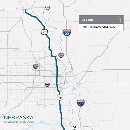
Due to rising water levels, if I-29 is closed, use US-75 as a recommended route for travel in and out of Omaha.
Stay updated by following Iowa Department of Transportation. If you see water over the road, turn around - don't drown!
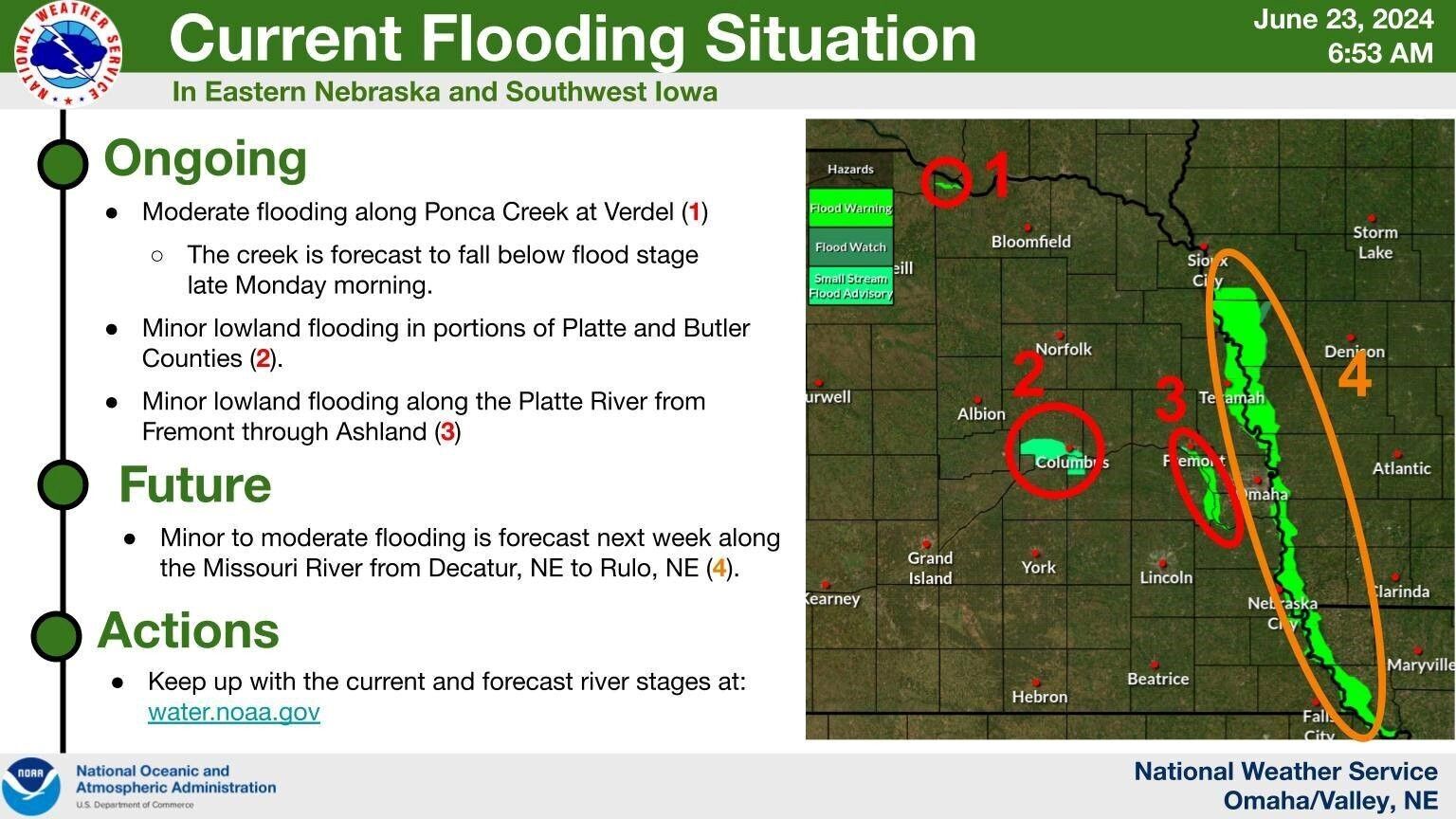
6-23-2024
Flood warnings along the Platte River overnight from Fremont down through Ashland. Here is the current flooding situation across eastern NE and southwest IA. Keep up with the current and forecast river stages at: water.noaa.gov